Ashland County, Ohio
Ashland County is a county in the U.S. state of Ohio. In 2020, 52,447 people lived there.[2] The county seat is Ashland.
| Ashland County, Ohio | |

| |
| Map | |
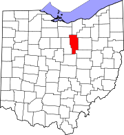
 Location in the state of Ohio | |
 Ohio's location in the U.S. | |
| Statistics | |
| Founded | February 24, 1846[1] |
|---|---|
| Seat | Ashland |
| Largest City | Ashland |
| Area - Total - Land - Water |
427 sq mi (1,106 km²) 423 sq mi (1,096 km²) 3.8 sq mi (10 km²), 0.9% |
| Population - (2020) - Density |
52,447 auto/sq mi (Expression error: Unrecognized word "auto"./km²) |
| Time zone | Eastern: UTC-5/-4 |
| Website: www.ashlandcounty.org | |
| Named for: "Ashland", Henry Clay's home | |
Geography
The county has a total area of 427 square miles (1,110 square kilometers).
Communities
City
- Ashland (county seat)
Villages
Townships
- Clear Creek
- Green
- Hanover
- Jackson
- Lake
- Mifflin
- Milton
- Mohican
- Montgomery
- Orange
- Perry
- Ruggles
- Sullivan
- Troy
- Vermillion
Census-designated place
Other unincorporated communities
- Albion
- England
- Five Points
- Herefork
- Lake Fork
- McKay
- McZena
- Mohicanville
- Nankin
- Nova
- Paradise Hill
- Redhaw
- Rowsburg
- Ruggles
- Spreng
- Sullivan
- Widowville
Ashland County, Ohio Media
References
- ↑ "Ohio County Profiles: Ashland County" (PDF). Ohio Department of Development. Archived from the original (PDF) on 8 May 2007. Retrieved 2007-04-28.
- ↑ "QuickFacts: Ashland County, Ohio". United States Census Bureau. Retrieved January 18, 2024.