File:Central europe 1572.png
Size of this preview: 628 × 599 pixels. Other resolutions: 251 × 240 pixels | 503 × 480 pixels | 629 × 600 pixels | 922 × 880 pixels.
Original file (922 × 880 pixels, file size: 120 KB, MIME type: image/png)
| This is a file from the Wikimedia Commons. The description on its description page there is shown below.
|
Summary
| Description |
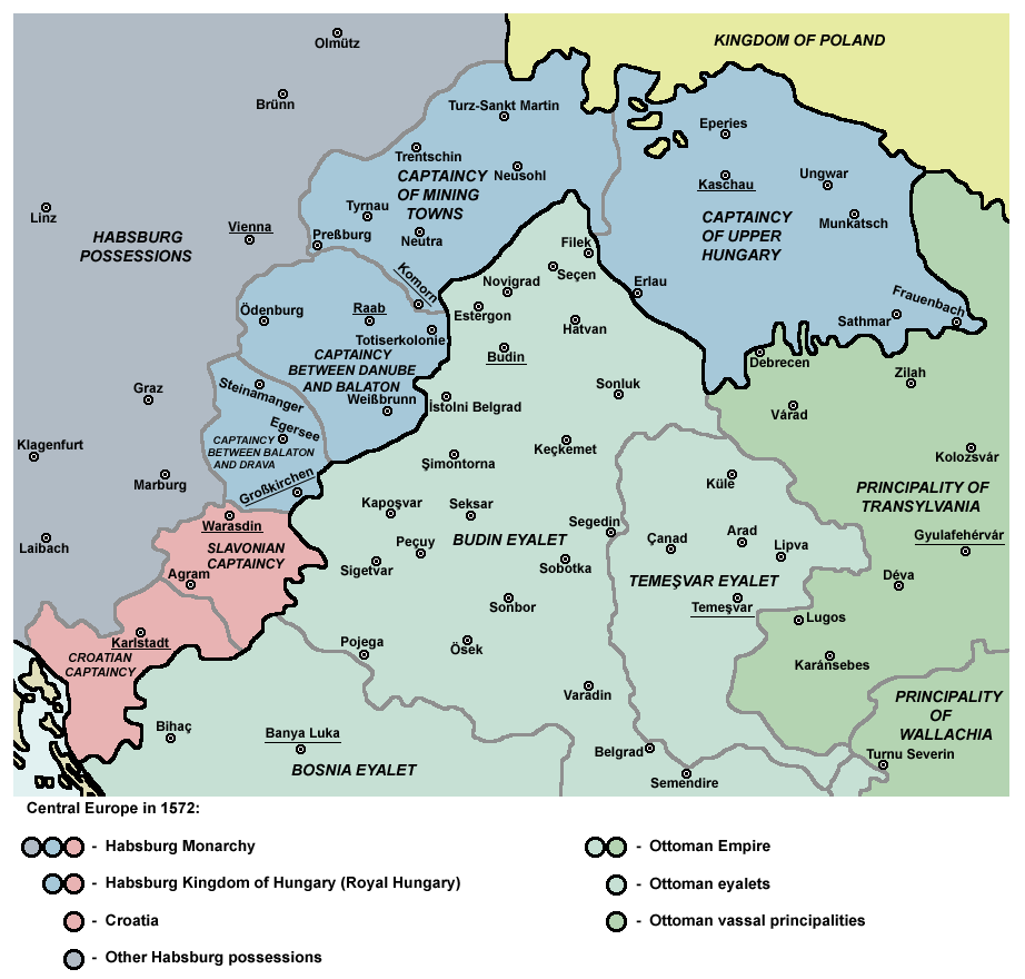
English: Captaincies of the Kingdom of Hungary in 1572: Habsburg Hungary (Royal Hungary), Habsburg Slavonia, Habsburg Croatia, Ottoman Budin Eyalet, Ottoman Temeşvar Eyalet. |
| Date | |
| Source | Own work |
| Author | PANONIAN |
| Other versions |
|

Licensing
I, the copyright holder of this work, hereby publish it under the following license:
| This file is made available under the Creative Commons CC0 1.0 Universal Public Domain Dedication. | |
| The person who associated a work with this deed has dedicated the work to the public domain by waiving all of their rights to the work worldwide under copyright law, including all related and neighboring rights, to the extent allowed by law. You can copy, modify, distribute and perform the work, even for commercial purposes, all without asking permission.
|
References
- http://www.sulinet.hu/eletmod/hogyantovabb/tovabbtanulas/elokeszito/tortenelem/6het/map.jpg
- http://honismeret.uw.hu/pictures/history/oszman_torok_birodalom_big.jpg archive copy at the Wayback Machine
- http://www.kepido.oszk.hu/attachments/images/nagy/pe94122.jpg
- http://mek.niif.hu/01800/01885/html/cd5m/kepek/nyelvtortenet/ny251pe94122.jpg
- http://mek.oszk.hu/01800/01885/html/cd5m/kepek/c4341pe94122.jpg
- http://mek.oszk.hu/01800/01885/html/cd5m/kepek/tortenelem/to321pe94123b.jpg
- http://hu.wikipedia.org/wiki/Fájl:Torokvilag.jpg[dead link]
- http://www.sulinet.hu/oroksegtar/data/telepulesek_ertekei/Erd/pages/images/221.jpg
- http://xxlworld.xx.ohost.de/povijest/slike/mape/1606.jpg
- http://www.hic.hr/books/pavlicev/images/s05.gif archive copy at the Wayback Machine
- The Times History of Europe, Times Books, London, 2002.
- Peter Rokai - Zoltan Đere - Tibor Pal - Aleksandar Kasaš, Istorija Mađara, Beograd, 2002.
- Dr Dušan J. Popović, Srbi u Vojvodini, knjiga 1, Novi Sad, 1990.
- Dr D. J. Popović, Vojvodina u tursko doba, Zbornik "Vojvodina", knjiga I, Fototipsko izdanje, PROMETEJ, Novi Sad, 2008.
- Halil Inaldžik, Osmansko carstvo, Beograd, 2003.
File history
Click on a date/time to view the file as it appeared at that time.
| Date/Time | Dimensions | User | Comment | |
|---|---|---|---|---|
| current | 03:36, 5 September 2011 | 922 × 880 (120 KB) | PANONIAN | {{Information |Description ={{en|1=Map of Central Europe in 1572: Habsburg Kingdom of Hungary (Royal Hungary), Habsburg Croatia, Ottoman Budin Eyalet, Ottoman Temeşvar Eyalet. }} |Source ={{own}} |Author =PANONIAN |Da |
File usage
The following page uses this file: