File:Dujiang Weir.jpg

Size of this preview: 800 × 337 pixels. Other resolutions: 320 × 135 pixels | 640 × 270 pixels | 1,024 × 432 pixels | 1,280 × 539 pixels | 9,288 × 3,914 pixels.
Original file (9,288 × 3,914 pixels, file size: 23.05 MB, MIME type: image/jpeg)
| This is a file from the Wikimedia Commons. The description on its description page there is shown below.
|
Summary
| Description |
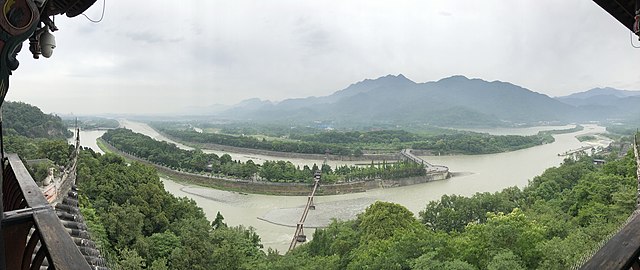
中文:都江堰全景
English: Dujiangyan Irrigation System, Chengdu, Sichuan, China |
| Date | |
| Source | Own work |
| Author | 星星 |
| Other versions |
.jpg)
| Camera location | | View this and other nearby images on: OpenStreetMap |
|---|
Licensing
I, the copyright holder of this work, hereby publish it under the following license:
This file is licensed under the Creative Commons Attribution-Share Alike 4.0 International license.
- You are free:
- to share – to copy, distribute and transmit the work
- to remix – to adapt the work
- Under the following conditions:
- attribution – You must give appropriate credit, provide a link to the license, and indicate if changes were made. You may do so in any reasonable manner, but not in any way that suggests the licensor endorses you or your use.
- share alike – If you remix, transform, or build upon the material, you must distribute your contributions under the same or compatible license as the original.
| Annotations | This image is annotated: View the annotations at Commons |
File history
Click on a date/time to view the file as it appeared at that time.
| Date/Time | Dimensions | User | Comment | |
|---|---|---|---|---|
| current | 23:07, 29 May 2020 | 9,288 × 3,914 (23.05 MB) | 星星 | 拍摄于2020年5月 |
File usage
The following 2 pages use this file: