File:Map Diego Ribero 1529.jpg
Original file (4,048 × 1,736 pixels, file size: 4.64 MB, MIME type: image/jpeg)
| This is a file from the Wikimedia Commons. The description on its description page there is shown below.
|
Summary
| Description |
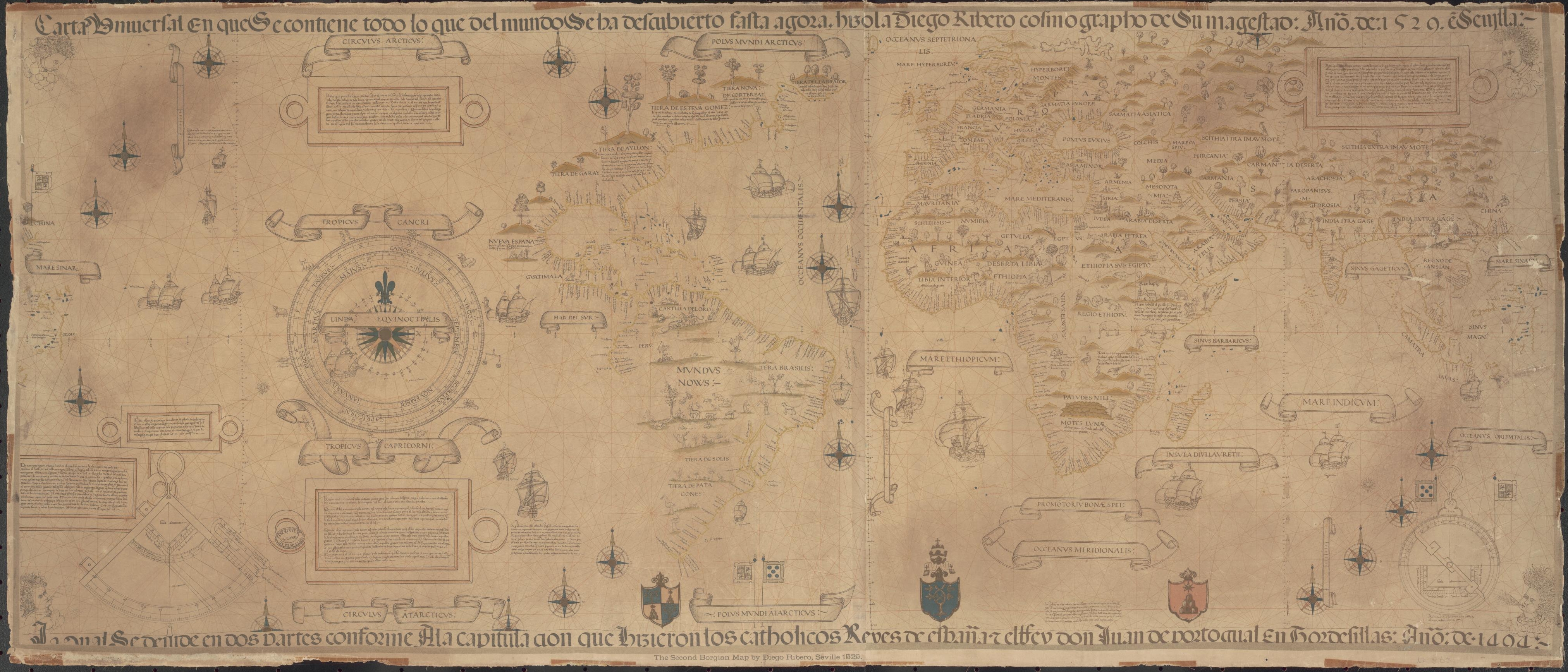
English: c. 1887 reproduction on two sheets (79×61 and 66×61 cm) of the 1529 Propaganda world map, believed to be a reproduction by Diogo Ribeiro of the Spanish Padron Real (Royal Standard Map) held at the Seville Casa de Contratacion (House of Trade). It shows Spanish uncertainty regarding the Pacific Coast of the Americas, the Spice Islands, and the exact details of locations around the Indian Ocean, while adding additional information from the expeditions of Magellan and others. Also known as the 1529 Weimar map, 1529 Ribeiro Planisphere, Second Borgian Map, or Carta universal en que se contiene todo lo que del mundo se ha descubierto fasta agora, hizola Diego Ribero cosmographo de su magestad, año de 1529, e[n] Sevilla / La cual se devide en dos partes conforme A la capitulacion que hizieron los catholicos Reyes de españa y el rrey don Juan de portogual En Tordesillas Año de 1494.
Español: Facsímil de la carta universal realizada por Diego Ribero en 1529.) Título original=Carta universal en que se contiene todo lo que del mundo se ha descubierto fasta agora, hizola Diego Ribero cosmographo de su magestad, año de 1529, e[n] Sevilla / La cual se devide en dos partes conforme A la capitulacion que hizieron los catholicos Reyes de españa y el rrey don Juan de portogual En Tordesillas Año de 1494 |
| Date |
1529 c. 1887 |
| Source | National Library of Australia, from an original in the Museum of the Propaganda (Palazzo di Propaganda Fide) in the Vatican City, believed to be a reproduction of the era's Padron Real in the Casa de Contratacion in Seville, Kingdom of Castile, Spain. |
| Author | Diego Ribero and William Griggs. Transferred from en.wikipedia to Commons by Jalo using CommonsHelper. |
| Other versions |
Derivative works of this file: Map Diego Ribero 1529 Asia.jpg |


Licensing
|
This is a faithful photographic reproduction of a two-dimensional, public domain work of art. The work of art itself is in the public domain for the following reason:
The official position taken by the Wikimedia Foundation is that "faithful reproductions of two-dimensional public domain works of art are public domain".
This photographic reproduction is therefore also considered to be in the public domain in the United States. In other jurisdictions, re-use of this content may be restricted; see Reuse of PD-Art photographs for details. | ||||
Original upload log
- 2008-01-24 01:18 Dominipater 4048×1736× (4860876 bytes) {{Information |Description=World Map |Source=Electronic |Date=1529 |Location=National Library of Australia |Author=Diego Ribero |Permission= |other_versions= }}
File history
Click on a date/time to view the file as it appeared at that time.
| Date/Time | Dimensions | User | Comment | |
|---|---|---|---|---|
| current | 10:51, 15 March 2009 | 4,048 × 1,736 (4.64 MB) | File Upload Bot (Magnus Manske) | {{BotMoveToCommons|en.wikipedia|year={{subst:CURRENTYEAR}}|month={{subst:CURRENTMONTHNAME}}|day={{subst:CURRENTDAY}}}} {{Information |Description={{en|World Map}} |Source=Transferred from [http://en.wikipedia.org en.wikipedia]; transferred to Commons by |
File usage
The following page uses this file: