File:Map of Arizona highlighting Maricopa County.svg

Size of this PNG preview of this SVG file: 487 × 599 pixels. Other resolutions: 195 × 240 pixels | 390 × 480 pixels | 487 × 600 pixels | 624 × 768 pixels | 832 × 1,024 pixels | 893 × 1,099 pixels.
Original file (SVG file, nominally 893 × 1,099 pixels, file size: 260 KB)
| This is a file from the Wikimedia Commons. The description on its description page there is shown below.
|
Summary
| Description |
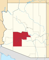
English: Locator map of Maricopa County in Arizona. |
||
| Date | |||
| Source | v.1: David Benbennick; v.2: File:USA Arizona location map.svg | ||
| Author | Own work. | ||
| Permission (Reusing this file) |
|
||
| Other versions | |||
| Commons images used |
- For more information, see Commons:United States county locator maps.
File history
Click on a date/time to view the file as it appeared at that time.
| Date/Time | Dimensions | User | Comment | |
|---|---|---|---|---|
| current | 15:13, 28 February 2015 | 893 × 1,099 (260 KB) | Sumiaz | Newer version based on File:USA Arizona location map.svg |
File usage
The following 29 pages use this file:
- Apache Junction, Arizona
- Avondale, Arizona
- Buckeye, Arizona
- Carefree, Arizona
- Cave Creek, Arizona
- Chandler, Arizona
- El Mirage, Arizona
- Fountain Hills
- Gila Bend, Arizona
- Gilbert, Arizona
- Glendale, Arizona
- Goodyear, Arizona
- Guadalupe, Arizona
- List of counties in Arizona
- Litchfield Park, Arizona
- Maricopa County, Arizona
- Mesa, Arizona
- Morristown, Arizona
- Paradise Valley, Arizona
- Peoria, Arizona
- Phoenix, Arizona
- Scottsdale, Arizona
- Sun City, Arizona
- Sun City West, Arizona
- Surprise, Arizona
- Tempe, Arizona
- Tolleson, Arizona
- Youngtown, Arizona
- Template:Maricopa County, Arizona