File:Sark Seigneurie.jpg

Size of this preview: 768 × 599 pixels. Other resolutions: 308 × 240 pixels | 615 × 480 pixels | 769 × 600 pixels | 984 × 768 pixels | 1,280 × 999 pixels | 4,356 × 3,399 pixels.
Original file (4,356 × 3,399 pixels, file size: 2.01 MB, MIME type: image/jpeg)
| This is a file from the Wikimedia Commons. The description on its description page there is shown below.
|
Summary
| Description |
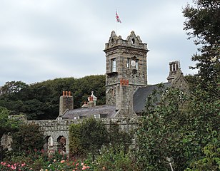
English: La Seigneurie (the governor's residence) on Sark, Channel Islands. |
| Date | |
| Source | Own work |
| Author | Daniel Kraft |
| Camera location | | View this and other nearby images on: OpenStreetMap |
|---|
Licensing
I, the copyright holder of this work, hereby publish it under the following license:
This file is licensed under the Creative Commons Attribution-Share Alike 3.0 Unported license.
- You are free:
- to share – to copy, distribute and transmit the work
- to remix – to adapt the work
- Under the following conditions:
- attribution – You must give appropriate credit, provide a link to the license, and indicate if changes were made. You may do so in any reasonable manner, but not in any way that suggests the licensor endorses you or your use.
- share alike – If you remix, transform, or build upon the material, you must distribute your contributions under the same or compatible license as the original.

|
This image has been assessed under the valued image criteria and is considered the most valued image on Commons within the scope: La Seigneurie. You can see its nomination here. |
File history
Click on a date/time to view the file as it appeared at that time.
| Date/Time | Dimensions | User | Comment | |
|---|---|---|---|---|
| current | 08:20, 7 June 2020 | 4,356 × 3,399 (2.01 MB) | Domob | Uploaded own work with UploadWizard |
File usage
The following page uses this file: