Plazas de soberanía
The plazas de soberanía (Spanish pronunciation: [ˈplaθas ðe soβeɾaˈni.a], lit. "strongholds of sovereignty")[3] is a term describing a series of Spanish overseas minor territories scattered along the Mediterranean coast bordering Morocco or that are closer to Africa than Europe. This term is used for those territories that have been a part of Spain since the formation of the modern country (1492–1556), as opposed to African territories acquired by Spain during the 19th and early 20th centuries in the Scramble for Africa.
 | |
| Country | Spain |
| Government | |
| • Type | De facto unincorporated area[1] under the administration of the Ministry of Defence[2] |
| Area | |
| • Total | 0.59 km2 (0.23 sq mi) |
| Time zone | UTC+01:00 (CET) |
| • Summer (DST) | UTC+02:00 (CEST) |
Historically, a distinction was made between the so-called "major places of sovereignty", comprising the autonomous cities of Ceuta and Melilla, and the "minor places of sovereignty", referring to a number of islands (and a small peninsula) along the coast. In the present, the term refers mainly to the latter.
- ↑ del Valle, Alejandro (20 December 2011). "Ceuta, Melilla, Chafarinas, Vélez y Alhucemas: tomar la iniciativa (ARI)". Real Instituto Elcano (in español). Archived from the original on 25 March 2020. Retrieved 25 March 2020.
- ↑ Mariñas Otero, Eugenio (1998). "Las Plazas Menores de soberanía española en África" (in es). MILITARIA. Revista de Cultura Militar. (Madrid: UCM) (12). https://revistas.ucm.es/index.php/MILT/article/download/MILT9898220141A/3364/0. Retrieved 25 March 2020.
- ↑ ASALE, RAE-; RAE. "plaza #3 == Plazas De Soberanía Media ==
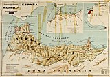
Map of Spanish Morocco in 1925
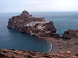
Peñón de Vélez de la Gomera, seen from the Moroccan coast, 2007
{{cite web}}: line feed character in|title=at position 10 (help)

.jpg)
