File:Map of war in Yugoslavia, 1993.png

Size of this preview: 800 × 527 pixels. Other resolutions: 320 × 211 pixels | 640 × 421 pixels | 1,024 × 674 pixels | 1,280 × 842 pixels | 1,887 × 1,242 pixels.
Original file (1,887 × 1,242 pixels, file size: 195 KB, MIME type: image/png)
| This is a file from the Wikimedia Commons. The description on its description page there is shown below.
|

|
This military map image could be re-created using vector graphics as an SVG file. This has several advantages; see Commons:Media for cleanup for more information. If an SVG form of this image is available, please upload it and afterwards replace this template with
{{vector version available|new image name}}.
It is recommended to name the SVG file “Map of war in Yugoslavia, 1993.svg”—then the template Vector version available (or Vva) does not need the new image name parameter. |
Summary
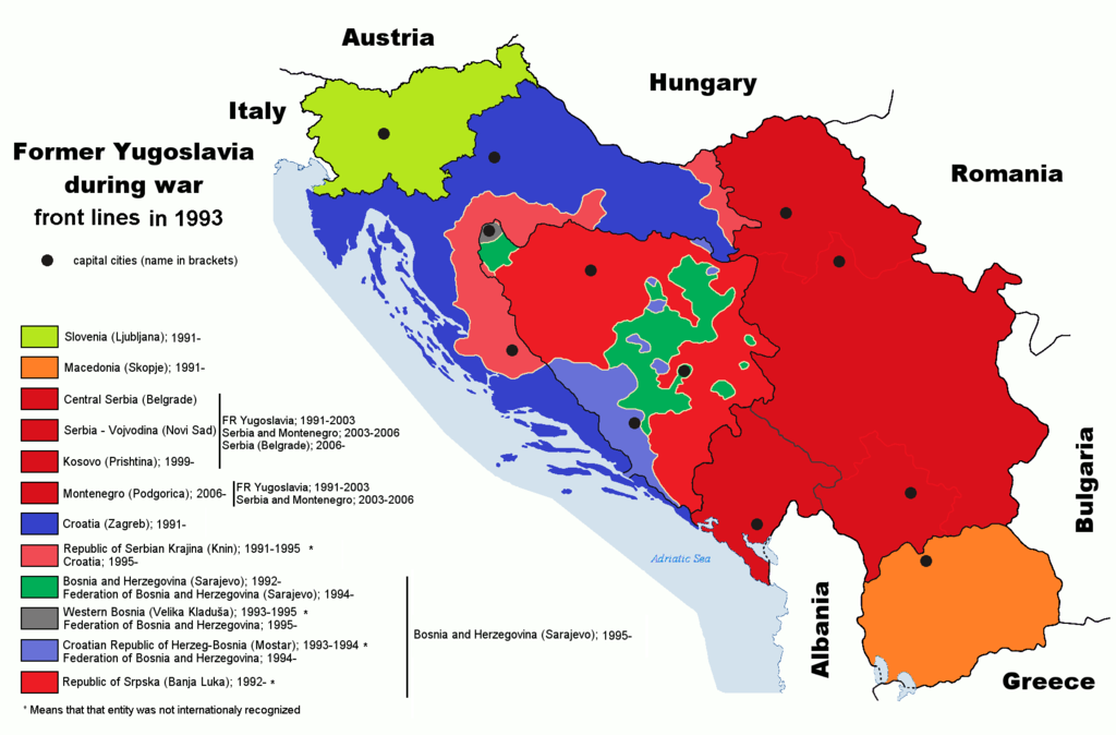
| Description | Map of former Yugoslavia during last wars. War political entities in Croatia and Bosnia-Herzegovia are marked |
| Date | 6 September 2006 (original upload date) |
| Source | English Wikipedia |
| Author | Paweł Goleniowski |
| Other versions |
|


Licensing
English Wikipedia user swPawel, the copyright holder of this work, hereby publishes it under the following license:

|
Permission is granted to copy, distribute and/or modify this document under the terms of the GNU Free Documentation License, Version 1.2 or any later version published by the Free Software Foundation; with no Invariant Sections, no Front-Cover Texts, and no Back-Cover Texts. A copy of the license is included in the section entitled GNU Free Documentation License. |
| This file is licensed under the Creative Commons Attribution-Share Alike 3.0 Unported license. | ||
| Attribution: English Wikipedia user swPawel | ||
| ||
| This licensing tag was added to this file as part of the GFDL licensing update. |
Original upload log
The original description page was here. All following user names refer to en.wikipedia.
- 2011-07-21 10:50 DIREKTOR 1887×1242× (101751 bytes) Colors
- 2011-07-21 01:14 DIREKTOR 1887×1242× (101751 bytes) Further
- 2011-07-21 01:05 DIREKTOR 1887×1242× (95186 bytes) rm IEBL
- 2011-07-20 21:29 DIREKTOR 1887×1242× (96335 bytes) Fixed hues
- 2011-07-20 19:33 DIREKTOR 1887×1242× (96341 bytes) Colors
- 2008-08-10 11:19 Ceha 1887×1242× (97449 bytes) Changed front lines around Bihać. See http://en.wikipedia.org/wiki/Image:Western_Bosnia_1994.png
- 2006-09-06 00:05 Ceha 1887×1242× (97506 bytes)
File history
Click on a date/time to view the file as it appeared at that time.
| Date/Time | Dimensions | User | Comment | |
|---|---|---|---|---|
| current | 11:07, 26 April 2023 | 1,887 × 1,242 (195 KB) | Drax90 | little fix: updated map |
File usage
The following 2 pages use this file: